Tartalomjegyzék
Tura útja és Szalmi története
Szalmi története
- apja a Karjalai Viipurban született; nagyapjának malma volt; apja 2m magas; cári hadsereg testőre Péterváron
- apja Penzából származó lányt vett el, akinek az apja szintén molnár
- első világháború kitörésekor Szalmi 6 éves volt (1908. körül született)
- mordvin nagyapja malmába I. Világháborús hadifoglyokat hoztak dolgozni; többen a polgárháborúban is harcoltak, ill. ott rekedtek; a malom körül kis magyar kolónia keletkezett
- Szalmi a leningrádi egyetem finnugor karán tanul nyelvészetet
- tanár lesz egy főiskolán
- hírszerzéshez vezénylik
- II. világháború egy tanfolyamon éri Leningrádban; harcol a védők között
- Ottó Kuusinen javaslatára a kijevi partizániskolába megy
- 13 fős csoportjuk ejtőernyővel a Sztrecsnó melletti tisztásra érkezik
Tura útja
gyermekkor
- az I. Világháborús hadifogoly, Zsiray Miklós (későbbi finnugor-nyelvész) megbetegszik; Tura nagyapja gyógyítja meg; a nagyapa beszélt neki rovásos feljegyzésekről és megígérte, hogy majd lemásolva eljuttatja őket neki
- Tura '45 elején 22 éves volt, így 1922 aug. 1. körül születhetett (nagyapja később a Feran alapján aug. 1-hez tartozó nevet ad neki sámánnévként)
- Tura Vezsakoriban született, az anyja volt odavalósi
- Tura apját még fiatalon a medve tépte szét, „mert hamisan esküdött”; a medvét Tura bátyja és nagyapja ölte meg
- a nagyapa minden télen rénszarvas szánon lement a turgai kapuba, mert az ő 26-ik manysi „fátriája” a 26-ik baskír-magyar családdal volt házassági rokonságban
- az apa halála után a nagyapa a két fiút bevitte a tajgába
- Tura megemlíti egy nővérét is (aki Tura 18 éves korában még az anyjával lakott)
- amikor a Lozva vidékén manysi nyelvű iskola nyílt, a nagyapa Tura bátyját elvitte; utána ő katona (haditengerész) lett
- valószínűleg Tura is oda járt; de ő a nyári szünetekben a nagyapjánál volt
- a nagyapa írni-olvasni nem tudott, fákra rótta az eseményeket; a nagyapa folyton régi történeteket mesélt
- a nagyapa szerint Dr. Zsiray Miklós hazájában lesz olyan ember, aki meg tudja érteni és tovább tudja adni az iratokat
ifjúkor
- Tura a nagyapja halálakor 12 éves volt (kb. 1934.)
- Tura a negyedik év végén beomlasztotta a nagyapa kegyhelyén Joli-Tórem hajlékát; magához veszi a Világügyelő Aranyfejedelem kegyhelyén őrzött Arvisurák, és rovók, aranyasszonyok feljegyzéseinek másolatait
- 1938-ban (1945 előtt hét évvel) tartottak medvetort Turáék Vezsakoriban, Tomaj Péterrel (tudományos kutató, akit manysi-földre küldtek) és Szurguti Mihállyal (aki ekkor a szurguti halfeldolgozó kombinátban dolgozott); Mihállyal később is találkozott, amikor halat adtak le a szurguti kombinátnak
- Tura az ötödik éves toron (kb. 18 évesen) ismerte meg a Keti nevű lányt, aki a mátkája lett
- ekkor Tura az anyjánál lakik (kb. 1940.)
- Tura egyszer halászni indult; váratlanul visszatérve a mátkáját rajtakapta egy másik legénnyel; Keti megesküdött a medvére, hogy nem történt semmi
- a kéthónapos vadászatról visszatérve Tura megtudja, hogy Ketit egy medve széttépte
Tura útja Penzáig
- egyik este elindult a Szoszván
- majd pár napig az Obon felfelé evez
- az Irtishez érve azon felfelé evez
- elhagyja a Tavdát és tovább evez
- eléri a Turát, a névadó folyóját, azon evez felfelé
- a hegyek aljánál fa- és földkonyhókhoz, oroszosan beszélő déli-manysikhoz ér; a nagyapja idevaló volt;
- megtudja, hogy kitört a háború; egy özvegyasszonynál telel ki
- elindul, Joli-Tórem ünnepénél már a Vasbálvány vidékén jár
- az Uralon átmenve a Kámához ér, útközben a Jajva melléki bálványtartó barlangban áldozatot mutat be Hadúr-Tóremnek
- a Káma mellett egy déli-komi családnál beállt halásznak; közben csónakot készített; közben Igor Tomaj a régi magyar nyelvre tanítgatta
- aratáskor Igor Tomaj behívót kapott
- Tura csónakon elindul az Etil-Volga felé
- Csebokszárihoz ért, amikor befagyott a Volga
- Az állambiztonság emberei elfogják; majd Szalmihoz viszik, hogy tolmácsoljon
- Szalmi Penzára, a szüleihez vitte el, ahol megtanult magyarul
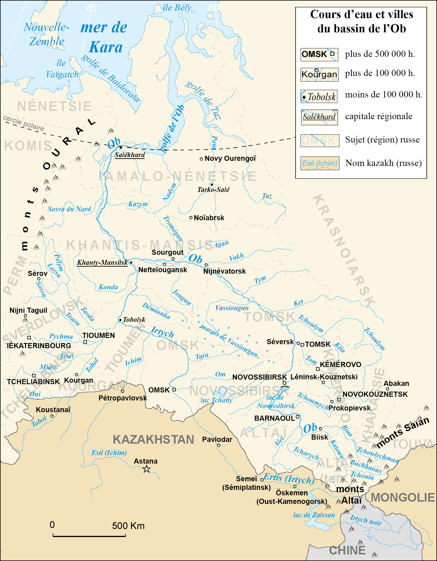
Az Ob vízgyűjtő területe egy francianyelvű térképen: http://upload.wikimedia.org/wikipedia/commons/3/38/Bassin-fluvial-de-l-Ob.png
- Vezsakori
- Ивдель, a Lozva mellett
- Északi-Szoszva torkolata (az Ob-folyóba)
- Irtis torkolata (az Ob-folyóba)
- Tobol torkolata (az Ob-folyóba)
- Tavda torkolata (a Tobol-folyóba)
- Tura torkolata (a Tobol-folyóba)
- Нижняя Тура
- Яйва város
- Jajva torkolata (a Káma folyóba)
- Csebokszári
- Penza
operating instructions
Various functions are available as part of the map.
mouse/touch operation
- moving by grabbing the map with a mouse-click you can move the map around
- overview map using the + button in the bottom right of the map you can expand an overview map
- zooming in and out using the + and - buttons in the top left of the map you can obtain more or less detail in the map
- switching themes or maps clicking on the ≡ icon on the right-hand side of the map you can view and select available maps and themes
- retrieving information the map may contain elements that contain more information, by clicking these a popup will show this information
- fullscreen display using the ✈ button the map can be maximized to fullscreen display, use the ✕ button to return to page display.
keyboard operation
Keyboard operation becomes available after activating the map using the tab key (the map will show a focus indicator ring).
- moving using the arrow keys you can move the map
- overview map using the + button in the bottom right of the map you can expand an overview map
- zooming in and out using the + and - buttons in the top left of the map or by using the + and - keys you can obtain more or less detail in the map
- switching themes or maps clicking on the ≡ icon on the right-hand side of the map you can view and select available maps and themes
- retrieving information the map may contain elements that contain more information, using the i key you can activate a cursor that may be moved using the arrow keys, pressing the enter will execute an information retrieval. press the i or the escape key to return to navigation mode
- fullscreen display using the ✈ button the map can be maximized to fullscreen display, use the ✕ button to return to page display.
It's possible that some of the functions or buttons describe above have been disabled by the page author or the administrator

| id | symbol | latitude | longitude | description |
|---|---|---|---|---|
| Tura útja | ||||
| 1 | 63.3881º | 65.547801º | Vezsakori (Vezhakorskiye) |
|
| 2 | 60.688767º | 60.423398º | Ивдель, a Lozva mellett |
|
| 3 | 63.516792º | 65.194848º | Északi-Szoszva torkolata (az Ob-folyóba) |
|
| 4 | 61.082076º | 68.833726º | Irtis torkolata (az Ob-folyóba) |
|
| 5 | 58.153176º | 68.216089º | Tobol torkolata (az Ob-folyóba) |
|
| 6 | 57.799641º | 67.255901º | Tavda torkolata (a Tobol-folyóba) |
|
| 7 | 57.211715º | 66.951717º | Tura torkolata (a Tobol-folyóba) |
|
| 8 | 58.575481º | 59.942254º | Нижняя Тура folyó |
|
| 9 | 59.337117º | 57.269992º | Яйва város |
|
| 10 | 59.310271º | 56.690806º | Jajva torkolata (a Káma folyóba) |
|
| 11 | 56.128541º | 47.275468º | Csebokszári |
|
| 12 | 53.193983º | 45.012116º | Penza |
|
Tura útja Magyarországra
- amikor Szalmi Leningrádból visszatért, Tura és Rigó jelentkeztek a kijevi partizániskolába
- előttük a ózd-vajdavári csoportot (vagyis Szőnyiéket) dobták le
- először Szőnyiék indultak; velük ment Szurguti Iván robbantó (a történelem a Szőnyi-csoport robbantóját Zsiljajev néven ismeri)
- egy óra múlva indul Turáék repülője; vele ment Szurguti Mihály
- a rádió elromlott, nem tudtak Szőnyiékkel beszélni; tévedésből Fülek mellett, a Poltár melletti országhatár közelében dobták le őket; másutt (219.o) Tura azt mondja, hogy Magyarhegymegen ugrott
- katonaság kutatta át az erdőt, de Turának sikerült megmenekülni, mert Biricsák Mari juhászlány elbújtatta
- Szőnyiék csoportját időközben elfogják és megölik, ill. Miskolcon őrzik
- Szurguti Mihálynak sikerült Poltárra eljutni
- a „részeges orvos” és Iván a két rádióssal szintén Poltáron van
- a Sztrecsnón ledobott Szalmi és Rigó Szőnyivel találkozott volna, de így csak Poltárig jut
- következő hónapban Tura és Mari bemennek Miskolcra, és „kis ügyeskedéssel” sikerül beszélni Tura fogva tartott társaival („Sikerült beszélni a Füleken és Vajdaváron elfogott társainkkal”, vagyis Füleken is fogtak el partizánokat.)
- az elfogottak között volt a „mezőkövesdi fiú”
- a Népkertben ebédelnek, bombázás, Biricsák Mari meghal
- (A szövetséges erők repülőgépei olaszországi támaszpontjukról 1944. június 2-án először és azt követően még augusztus 22-23-án, augusztus 28-án, szeptember 13-án és október 21-én hajtottak végre légicsapást Miskolc ellen.)
- 44. aug. 22-23, Miskolc: bombázás
- 44. aug. 28, Miskolc: vasútállomás bombázása (a Népkert csak kb. 1km-re van a Tiszai pályaudvartól, így valószínűleg ekkor halt meg Biricsák Mari)
- 44. szept. 13, Miskolc: kohászati üzem és gépgyár bombázása
- Miskolcon megtudják, hogy Szőnyi még él. Szalmi, Rigó, Tura megkeresik
- 44. szept. 8: beszélnek Szőnyivel, hogy kiviszik az országból, de Szőnyi az eredeti terv szerint a kormánnyal akar tárgyalni; Pestre a bánrévei repülősök segítségével tervezi, hogy feljut
- 44. szept. 9: Szőnyire hajnalban rátörnek és agyonlövik.

